[Brought to you by our partners at AccuWeather.com and the National Weather Service]
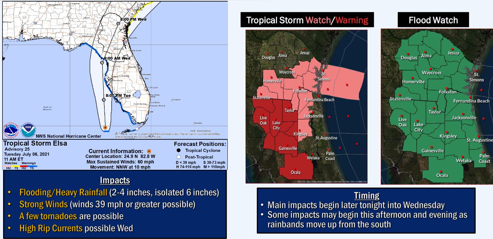
Final preparations were being rushed to completion across Florida and the Southeast Tuesday as Tropical Storm Elsa closed in on the Sunshine State, unleashing torrential rain and strong winds across the Florida Keys. AccuWeather forecasters say that the system will gradually strengthen over the warm waters of the Gulf of Mexico as it churns west of the state into early Wednesday morning, and it is possible Elsa could regain hurricane status, with sustained winds of 74 mph or greater, prior to striking land.
Elsa is projected to make landfall north of Tampa early Wednesday, and it has been rated as less than one on the AccuWeather RealImpact Scale for Hurricanes, due to the system’s expected rainfall, storm surge flooding, and the potential for damaging winds.
“Whether Elsa becomes a low-end Category 1 hurricane or remains a strong tropical storm, there may be little different with impacts,” AccuWeather Meteorologist Jake Sojda said, adding that slow strengthening is possible rather than another round of rapid intensification.
Tropical Storm Elsa was located about 215 miles south of Tampa, Florida, at 11 a.m. EDT Tuesday, with maximum sustained winds of 60 mph. It was moving toward the north-northwest at 10 mph.
TROPICAL STORM WARNING REMAINS IN EFFECT FOR CENTRAL MARION
- Anthony
- Burbank
- Ocala
- Weirsdale
Threats
WIND
– LATEST LOCAL FORECAST: Below tropical storm force wind
– Peak Wind Forecast: 20-30 mph with gusts to 40 mph
– THREAT TO LIFE AND PROPERTY THAT INCLUDES TYPICAL FORECAST
UNCERTAINTY IN TRACK, SIZE, AND INTENSITY: Potential for wind 58
to 73 mph
– The wind threat has remained nearly steady from the previous assessment.
– PLAN: Plan for the dangerous wind of equivalent strong tropical storm force.
– PREPARE: Remaining efforts to protect life and property should be completed as soon as possible. Prepare for significant wind damage.
– ACT: Move to a safe shelter before the wind becomes hazardous.
– POTENTIAL IMPACTS: Significant
– Some damage to roofing and siding materials, along with damage to porches, awnings, carports, and sheds. A few buildings experiencing window, door, and garage door failures. Mobile homes damaged, especially if unanchored. Unsecured lightweight objects become dangerous projectiles.
– Several large trees snapped or uprooted, but with greater numbers in places where trees are shallow-rooted. Several fences and roadway signs blown over.
– Some roads impassable from large debris, and more within urban or heavily wooded places. A few bridges, causeways, and access routes impassable.
– Scattered power and communications outages, but more prevalent in areas with above-ground lines.
* FLOODING RAIN
– LATEST LOCAL FORECAST: Flood Watch is in effect
– Peak Rainfall Amounts: Additional 2-4 inches, with locally
higher amounts
– THREAT TO LIFE AND PROPERTY THAT INCLUDES TYPICAL FORECAST
UNCERTAINTY IN TRACK, SIZE, AND INTENSITY: Potential for moderate flooding rain
– The flooding rain threat has remained nearly steady from the previous assessment.
– PLAN: Emergency plans should include the potential for moderate flooding from heavy rain. Evacuations and rescue are possible.
– PREPARE: Consider protective actions if you are in an area vulnerable to flooding.
– ACT: Heed any flood watches and warnings. Failure to take action may result in serious injury or loss of life.
– POTENTIAL IMPACTS: Significant
– Moderate rainfall flooding may prompt several evacuations and rescues.
– Rivers and tributaries may quickly become swollen with swifter currents and overspill their banks in a few places, especially in usually vulnerable spots. Small streams, creeks, canals, and ditches overflow.
– Floodwaters can enter some structures or weaken foundations. Several places may experience expanded areas of rapid inundation at underpasses, low-lying spots, and poor drainage areas. Some streets and parking lots take on moving water as storm drains and retention ponds overflow.
- Driving conditions become hazardous. Some road and bridge closures.
* TORNADO
– LATEST LOCAL FORECAST:
– Situation is favorable for tornadoes
– THREAT TO LIFE AND PROPERTY THAT INCLUDES TYPICAL FORECAST
UNCERTAINTY IN TRACK, SIZE, AND INTENSITY: Potential for several tornadoes
– The tornado threat has remained nearly steady from the previous assessment.
– PLAN: Emergency plans should include the potential for several tornadoes with a few possibly intense having larger damage paths.
– PREPARE: Those living in manufactured homes or on boats are urged to relocate to safe shelter before hazardous weather arrives.
– ACT: Listen for tornado watches and warnings. If a tornado warning is issued, be ready to shelter quickly.
– POTENTIAL IMPACTS: Significant
– The occurrence of scattered tornadoes can hinder the execution of emergency plans during tropical events.
– Several places may experience tornado damage with a few spots of considerable damage, power loss, and communications failures.
– Locations could realize roofs torn off frame houses, mobile homes demolished, boxcars overturned, large trees snapped or uprooted, vehicles tumbled, and small boats tossed about. Dangerous projectiles can add to the toll.

